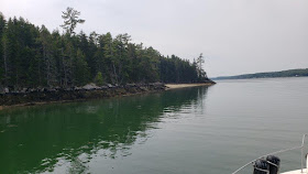
The morning began with fog but it was not the "so dense it will never burn off" type. And as predicted the fog scaled up nicely about mid morning.
Our trip today was a distance as the crow flies of about 6 miles from Maple Juice Cove to Greenland Cove. But with all the twists and turns - very nice ones I might add - it was just about double the straight, but not possible, route.
Our trip also started in the fog but it scaled up nicely after several miles of navigation by instruments versus by sight.
Our circuitous route included passing the village of Friendship. It is a lobster boat town with no pretense to want to cater to pleasure craft - thus the name of the town seems very contrary to their welcome mat.
A nice scene at low tide.
The mainland on the right and Hog Island on the left.
The Audubon Society camp building on the Hog Island
The very narrow but beautiful passage by Hog Island. Our destination of Greenland Cove is just up ahead and to the right.
We dinghied over to Hog Island and hiked the east side trail.
An old outhouse for the audubon camp
A plaque regarding the formation of the island as a public place
Some of the Audubon buildings used for meals and meeting - not being used this year. But the sounds of ongoing repair projects could be heard emanating from this building
The late afternoon brought a very strong band of thunderstorms moving over us from the west.
These aerial shots were taken after we had weathered the storm - and enjoyed a fine dinner of stuffed pasta shells.
The sky did have this very strange looking color of purple. It seemed a little ethereal.
The night has "scaled up" and the day has scaled down, so time to say ...................
Good Night and May God Bless


No comments:
Post a Comment
Please feel free to leave a comment. Would enjoy hearing your thoughts on the blog.