Wednesday, October 9, 2019

NH White Mountains Wednesday October 9, 2019

The day was mostly sunny through early afternoon then clouds increased. Temperatures were in the upper 50s with calm winds. A wonderful day to see the sights.

Last year we were on the Great Loop. This time last year we were on the Tennessee River.  We were ahead of the fall colors and we were in wonderful short sleeve and shorts weather.

But there was a down side to the wonderful temperatures - we missed the seasons. So being back home has once again allowed us to enjoy the transformation of the seasons. One day that we were especially looking forward to was a drive into the White Mountains of New Hampshire. They are about 100 miles north of us and situated to allow for a wonderful day trip - and today was the day.

Here are some photos of our most enjoyable day in the mountains.

The first stop was to walk the The Flume Gorge. It is a State Park. I am embarrassed to admit that I have only done the walk once and that was when I was growing up and my parents took us as kids.  Faye had never been, Great day to rectify that.


From the welcome center we walk a ways before the Flume and there are several wonderful vistas.


There is also a wonderful covered bridge, that from the date, you can see that it has been there for many years.  There is a bus from the visitor center than still uses the bridge.


Before we reach the gorge, we came upon this interesting flow over a rock face. Don't imagine there was much debate on what to call it.


Shortly we are at the beginning of the Flume Gorge.


After walking the Flume, the trail wanders nicely thorough the woods with a few overlooks.


The Pool is an interesting formation in the rock made by the river.


And there is a second covered bridge - pedestrian only


The mountains are Liberty to the left and Flume Mountain in the middle - where the water for the gorge originates.


A closer view of Flume mountain with its landslide face. There is a trail up it but I will pass based on the reviews of the last half mile being very steep - it sure looks like it from here, eh?


After the Flume we head back south a few miles to Lincoln and the start of the Kancamagus Highway. This road crosses through Kancamagus Pass at 2855'. Just before the peak there are several overlooks that provide wonderful views to the west.


And on the other side of the pass is views looking east.


The Bear Notch Road connects with the Kancamagnus Highway. It runs west to east and ends in Bartlett. This view includes a wonderful scene that includes Mountain Washington - center and in the distance in the photo below.


And a telephoto view


We have now driven north from Bartlett. This is the view looking south from nearly the top of Crawford Notch.


We drove to Twin Mountain and then headed west to connect to the I-93 parkway that will go south and complete our wonderful loop.

A few miles north of the Flume is the Basin. This is the stream that feds the Basin - and it has some interesting "twists and turns" before the basin.


And this is the Basin - amazing to think of the countless years of scour it took to create such an interesting formation. One has to wonder how long the overhanging rock with survive the freeze/thaw cycles. I am sure it has a few more years - lest you worry.


And so ends a fine day in our "own backyard." So it must be time to say ........

Good Night and May God Bless


Monday, September 9, 2019

Robinhood Marina to Jewell Island Monday September 9, 2019

The night was cool - fall is in the air - and calm. Partly cloudy skies remained through the night and all through the day. The wind was a near calm all day.  Temperatures in the upper 60s.

Well it is time to move the boat to New Hampshire for winter storage. It seems so strange to be thinking about taking the boat out of the water. It has been our floating home for most of the last 16 months.

As I discussed in the closing thoughts on the Great Loop, we really would enjoy having the boat back at Longboat Key - but the trip down by boat just seemed like to much effort, time and expense. The other consideration that I had thought about was having to be concerned about hurricanes. If you are reading this immediately after posting, you will recall the passage of Hurricane Dorian. It even just grazed Maine this past weekend and paid a direct visit to Nova Scotia. So it affirmed my thoughts that the trip down would also be a constant game of weather roulette - not something we would enjoy.

But on the other hand we are enjoying an easy ride to Portsmouth. We traveled from home today and left Robinhood about 11:30. The total trip is about 77 miles. Today we traveled about 23 miles to Jewell Island in Casco Bay, located about six miles shy of Portland.

Here we are passing by Macmahan Island to the left and the mainland to the right to get to the open water


We pass the area of Five Islands a short time later.


After rounding Griffin Head and Reid State Park, we pass by Seguin Island at the mouth of the Kennebec river. It is an amazing island, with a wonderful light house from 1873. The lighthouse keepers home is now restored and a marvelous place to visit.


Fuller Rock below.............


...... and Small Point to starboard appear. We have passed though here countless times, first in trips we made from Portland years ago with the sailboats and now with the powerboat at least in the spring and fall (except last year).


The buoy below marks the westerly approach.


After about another 8 miles we are approaching Jewell Island.


And its harbor located in the northeast side.


 It is an amazing island and in the public domain. The harbor once was clogged with moorings that people thought entitled them to the prime spots when they want to be there. Fortunately the town had all the mooring removed and it is a great place to anchor. We only ended up sharing it with a very small sailboat and a much larger one. The shots below are from the boat. We didn't go ashore this time as the weather was not the best and we wanted to watch the Pats defeat the Steelers - now that was great fun.


Right after a tasty steak, potato and Caesar salad dinner, I was able to fly the drone. Here are some really nice shots.


The feature in the upper half of the photo is called the "PunchBowl."  It is fun to walk to it.


Looking northeast back toward Harpswell.


The "H" of Cliff Island can be easily seen here.


Looking from the head of the cove back toward us.


And now looking southerly to the head of the harbor.


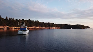
The sun has managed to come out. The shale rocks on the edge of the island look almost like they are on fire.


Well, we are ready to sleep and move early tomorrow so it is time to say ..........................

Good Night and May God Bless