Day 58 Sandy Bay to Black Bay Monday July 16, 2018
The night
was cool and clouds thickened overnight. It was hazy sun to start and there
were threats of thunderstorms – threatening clouds developed and a squall warning
made me nervous – but the storms stayed to the south of us. Sun came out at evening
time.
Note: Add your email above to receive email updates of postings. Must be in "Desktop Version" to see Email sign up line. If using mobile. there is a link beneath the Home button at end of the post. Be sure to verify confirming email - check spam if you don't get one
The ride
today was a relatively long one of 31 miles. It included a few twists and turns
through the islands and transiting the westerly end of the channel to Point Au
Baril that goes east to the small town (which we didn’t pass).


And this was the strangest cottage we have seen. What surprises me is the lack of windows


There is a beautiful lighthouse, as you can see below, at Point Au Baril.


And for today’s Blue Clues, why is the Point named that?

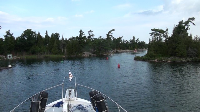
From the lighthouse we followed the small boat channel that eventually lead out to “open” water instead of going straight out from the lighthouse. The quotation marks are to highlight that open water is a relative term. True you could go out for a number of miles straight from Point Au Baril and get real deep water, but there is a small boat channel marked that allows you to play in the open water and be in the middle of the rocks Here is one tight sport that let's you sharpen you helmsman skills.


We had two choices – the main small boat channel that looked the easiest is not what this lad chose to do – nope – let’s go in the passage that has a tricky entrance and has two buoys that are spaced just about the width of my boat –after a hard turn to starboard, of course. This is not where one should go if there is ANY sea running. But we made it and after the entrance the rest of the route was fine – until we heard the emergency Coast Guard warning of squall possible for Georgian Bay. OK what to do.


And this was the strangest cottage we have seen. What surprises me is the lack of windows


There is a beautiful lighthouse, as you can see below, at Point Au Baril.


And for today’s Blue Clues, why is the Point named that?
Clue
1 It was named before the Lighthouse was erected.
Clue
2 This point was on the only nearby inlet from the open lake
Clue
3 Barll means “barrel” in French
Got
it? Clues are a little tougher on this one. The early settlers used this
passage a lot and marked the point with a barrel so you could distinguish one
land mass from another. At night they put a light on the barrel – hence Point
of the Barrel.
And
see it’s still here!! Just past the lighthouse.

From the lighthouse we followed the small boat channel that eventually lead out to “open” water instead of going straight out from the lighthouse. The quotation marks are to highlight that open water is a relative term. True you could go out for a number of miles straight from Point Au Baril and get real deep water, but there is a small boat channel marked that allows you to play in the open water and be in the middle of the rocks Here is one tight sport that let's you sharpen you helmsman skills.

We had perfect conditions as the cloud cover did not afford any
“sea” breeze to be generated and the squalls had not yet formed so off we went
in nearly calm seas. What a break. Our offshore
passage lasted about 15 miles and ended with the approach to Byng Inlet.
We had two choices – the main small boat channel that looked the easiest is not what this lad chose to do – nope – let’s go in the passage that has a tricky entrance and has two buoys that are spaced just about the width of my boat –after a hard turn to starboard, of course. This is not where one should go if there is ANY sea running. But we made it and after the entrance the rest of the route was fine – until we heard the emergency Coast Guard warning of squall possible for Georgian Bay. OK what to do.


I couldn’t find the weather alert the CG said to listen too but I did have a cell connection at the time. I could see a heavy band of rain to our south so decided to continue on to our planned anchorage rather than go to a marina up the Byng Inlet.
We continued
about another 3 miles to Black Bay.
It was uncharted as far as depth, but did appear to have the rocks marked. We worked our way into a wonderful spot where there were several other boats including a Bayliner 38 and 47.
It was uncharted as far as depth, but did appear to have the rocks marked. We worked our way into a wonderful spot where there were several other boats including a Bayliner 38 and 47.
The weather
seemed to be holding off on any thunderstorm so we were able to have a dinghy
ride among the many islands of the bay. What a place. Each anchorage has been
more spectacular than the last and this was not a disappointment. Exceptional
scenery and not a dwelling in sight – reminded me of some of the locations in
Nova Scotia we saw in 2015 – priceless.


The clouds
moved south near sundown and hinted at a nice day for tomorrow.
So as the
sun has set I will say…….
Good Night
and May God Bless
No comments:
Post a Comment
Please feel free to leave a comment. Would enjoy hearing your thoughts on the blog.